Memorial Day Weekend 2013
A great weekend, our son Andrew was visiting from Texas, so we all went hiking, kayaking, and flying.
The best part was flying over Ottawa County. Since I have lived here all my life, and I visit parks and places weekly, throughout the year with my sister Marie, I am quite familiar with this area. I particularly enjoyed flying over the Grand River and bayous.
I took tons of photos and it is great fun to identify what you are seeing below.
We took off from the Grand Haven airport in a rented Cessna 172 Skyhawk, four-seat, single-engine, high-wing fixed-wing aircraft. Andy piloted the plane.
Grand Haven, Michigan airport
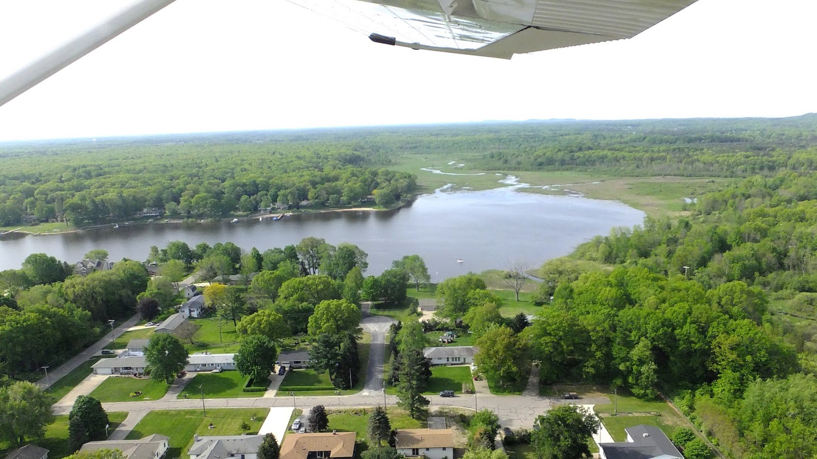
Our first trip up we flew east to Allendale, Michigan following along the Grand River. The picture below shows one of my favorite areas to hike, Bass River Recreation Area, owned by the State of Michigan. Also, Ottawa County Open Space Land, Bur Oak Landing. This shot is looking northwest.
Pottawattomie Bayou - just after take off.
See on the right side of this picture is the runway we just took off from.
Parts of Grand Haven, Ferrysburg, and Spring Lake are visible in this photo.
The US-31 drawbridge is center left, Lake Michigan is in the far upper left.
Center right is the float bridge snaking across the marsh at Hofma Preserve and Park, owned by Grand Haven Township.
Lake Michigan - Grand Haven north and south piers
I will need a few weeks to sort the hundreds of aerial shots from that day.
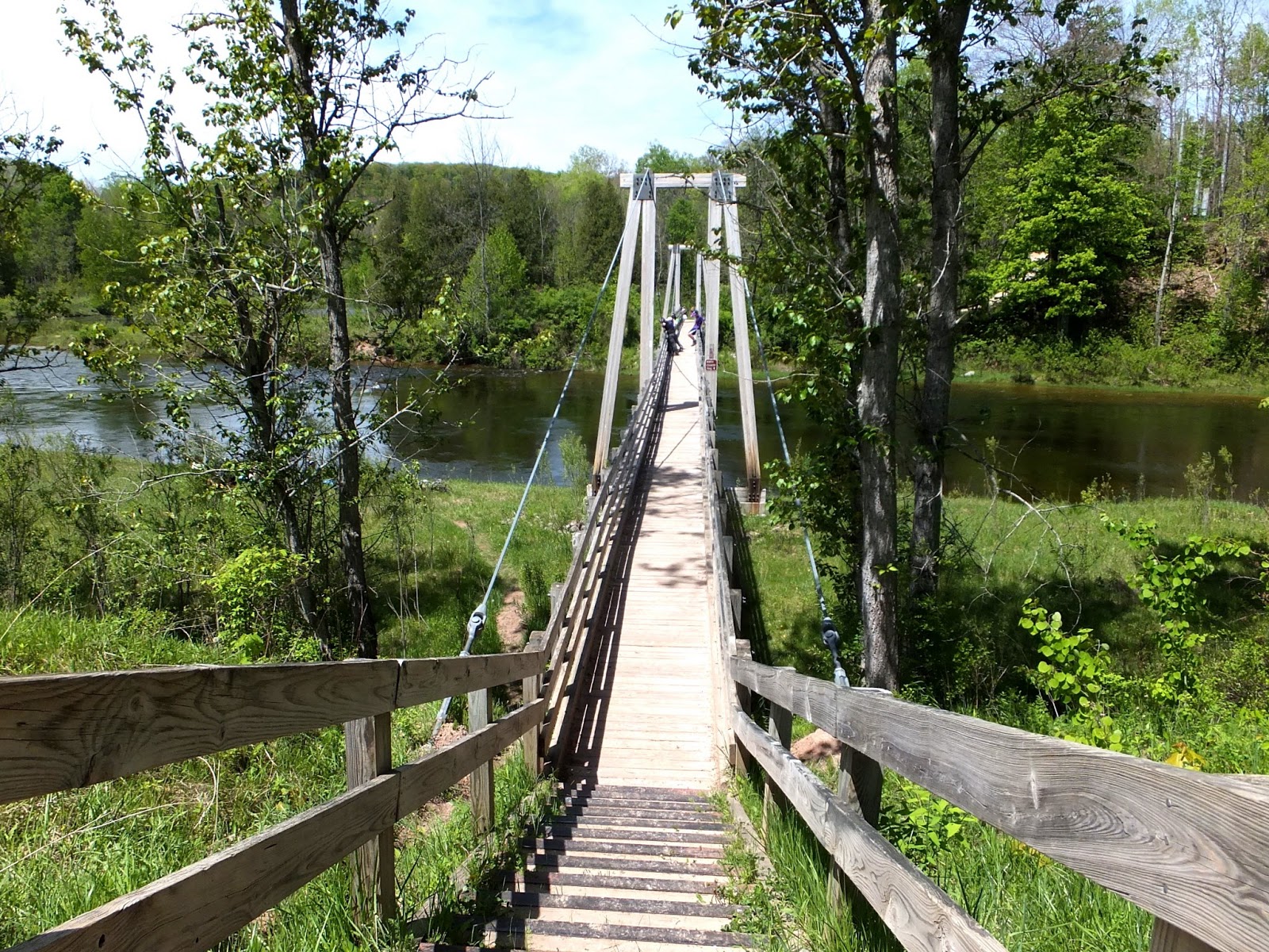
Saturday we took a day trip to hike the Manistee River trail.
On the flats along the Manistee River I found Indian Paintbrush (Castilleja coccinea) blooming. This plant is in the Figwort family and is usually found in moist meadows.
This is the suspension footbridge across the Manistee River below Hodenpyl Dam. It links the Manistee River Trail on the east side of the river with a section of the national North Country Trail on the west side. This creates a 20-mile loop hiking experience where wildflowers, wildlife, and bird species are common sites. We walked to the waterfalls and back, not the 20 mile loop.
Family and fun - a great weekend!


8 comments:
Oh wow. I found this way late tonight, just as I was shutting down. These aerial shots are so good. Wish I had been there! M :)
Searching for plants by plane is something new! You sure have a lot of water there-it's a beautiful place, even from the air.
Love the photos! That is so fun that Andy took you up flying... how cool! :-)
I loved the aerial photos, they added a lot of context to an area that I am familiar with, and I love the Manistee! I need to get up there and do a combination hike and paddle!
Marie, I wish you could have gone up with us too (you were working), I'm sure Andy would be glad to take you up. You and I have covered so much territory, especially in Ottawa County, and it is all down there for you to see!
:)
Some hot, buggy days Marie and I have looked for wildflowers by car.
It is amazing the amount of water compared to land! I could have flown around all day, I think we were up for over 90 minutes. We landed several times to change passengers but I got to go up every time. Fun!
Hey Shelly your mother made you come to the blog right? Andy is fun and cool, as are all our children, and nieces, nephews, grandchildren...okay you get the idea. Thanks for visiting the blog, and sending your mother to visit us.
:)
The aerial views, that's why I like Bing maps, it helps put things in perspective. Yes, go
to Manistee if you can (oh oh gas is $4.30!), we saw many birds along with wildflowers.
:)
Post a Comment